Die Struktur des Chicxulub-Impaktkraters in Yucatan/Mexiko - Eine 3D-Schweremodellierung
Zusammenfassung
Thema dieser Arbeit ist die Untersuchung der Impaktstruktur von Chicxulub in Yucatan/Mexiko. Der Impakt fand vor 65 Millionen Jahren an der Kreide-Tertiär-Grenze in einem Flachwassebereich statt und schuf eine Struktur eines Durchmessers von mindestens 180 km. Diese ist gut erhalten, da sie durch tertiäreSedimente bedeckt und erhalten wurde und gibt somit die Möglichkeit einen großen terrestrischen Impaktkrater zu studieren. Die Fragestellungen, die auftreten, sind die Frage nach seiner genauen Größe, nach seiner inneren Struktur (Multiring-Becken oder Peak-Ring-Krater) und seiner Morphologie. Die Beantwortung dieser Fragen kann wichtige Aufschlüsse für die Einschätzung seiner globalen Folgen geben. Über die Ausnutzung von seismischen Profile, Bohrlochdaten, Potentialfeldern und Modellvorstellungen, wurde versucht die Impaktstruktur zu modellieren. Die Rekonstruktion der Paläotopographie des Kraters kommt zu dem
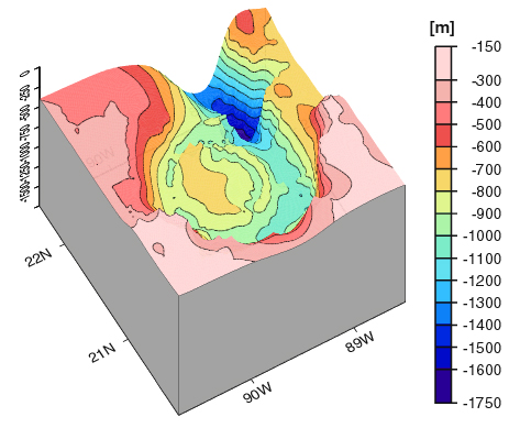
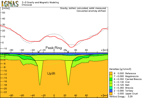
Ergebnis, daß der eigentliche Krater einen Durchmesser von ~140 km besitzt und daß sekundäre Effekte im Anschluß an den Impakt zu einer Erosion der topgraphischen Hochs und über einen längeren Zeitraum zur Bildung eines tiefen Beckens, das in den Krater einschneidet , führten. Der Vergleich von Paläotopographie und polreduzierter Magnetik zeigt eine Übereinstimmung in der Lage der zentralen Erhebung und der magnetischen Anomalien, die die Quelle dieser im Schmelzkörper vermuten läßt, der der Erhebung unterliegt. Die 3D-Schweremodellierung deutet ebenfalls auf einen Krater von ~140 km Durchmesser hin, was in Verbindung mit der in der Seismik erkennbaren Versetzung in einem Radius von 90 km, einen Hinweis liefert, daß es sich bei der Chicxulub-Struktur um ein Multiring-Becken handelt.
The structure of the Chicxulub impact crater at Yucatan/Mexiko - a 3D gravity modelling
Abstract
This study features the Chicxulub impact structure at Yucatan/Mexico. The impact has happened in a shallow water environment 65 Ma ago, i.e. at the K/T-boundary, and caused a structure of at least 180 km diameter. This structure should be well preserved, because of the tertiary sedimentary cover that buried the crater afterwards. Thus it is a good location to study a large terrestrial impact structure. The task is to explore the type of the structure (multiring-basin or peak-ring-crater), its size and morphology. Answering the questions above will help to understand the global effects of the impact. The geological impact structure was modeled by the use of potential field data, seismic profiles, borehole data and 2D stratigraphic models. Reconstructing the palaeotopography visualizes a crater of ~140 km in diameter smoothed by erosion and a deep basin in the north-west due to high energy oceanic wave action after the impact. Comparison of palaeotopography and RTP-magnetics shows a correlation of the positions of the central palaeotopograhic high and the magnetic anomalies, probably due to inherent qualities of the melt pool. The 3D-gravity modeling shows a crater of ~140 km in diameter, as well. Combining the results of gravity and seismic reflection this shows to be part of a larger structure 180 km in diameter, a hint to its origin as a multiring-basin.